
Tombstone Park, rivals Denali NP in some respects, but WITHOUT the crowds! It doesn’t have Denali Mt to look at. However in Denali, you have to take the shuttle bus (green school bus) into the park for at least a 6-8 hour ride for good views of Denali. (Only about 25% of the visitors get to see Denali Mt anyways) Tombstone has the open tundra county where you can take off in any direction and hike. There is some wildlife viewing. Not as much or as near as in Denali, but you are not confined to viewing from a school bus either. There are 3 maintained hiking trails not far from the CG. Additionally you don’t have to stay at the CG. You can boondock at a pullout about 4 miles past the CG or at another large pullout about 20 miles farther on up the the Dempster Hwy. More on the BD spot down near the bottom of this blog page.
Tombstone is a lot like what the US National Parks were like 50-70 years ago. No large crowds, fairly informal and freedom to wander around the park w/o lots of rules and restrictions. I’m not saying there are no rules, just very few signs saying “no access here”, “no whatever here”, etc.
Tombstone Park website.
Tombstone Park Resources:
- Planning a Trip to Tombstone Territorial Park (handout)

- Tombstone Territorial Park (brochure & map)
- The Dempster Highway Travelogue (booklet)
- Tombstone Territorial Park Management Plan
- More info about Tombstone & Dempster Hwy.
Dawson City to Tombstone and Tombstone CG.
About 25 miles down the Klondike Hwy towards Whitehorse turn north on the Dempster Hwy. There is credit card only fuel station at the intersection. Reports are you can boondock at or near the intersection.
Just after you turn onto the Dempster there is a pull off with a couple of Dempster Hwy information signs. If there are any road closures there should be a warning sign. When we arrived there was a warning that the Dempster was closed from flooding at about KM 136. We found out later there were several campers and RV’ers trapped north of the washout for about 3-4 days waiting for the flooding to subside and temporary repairs to the road were made.


The Dempster Hwy is ~450 miles of gravel road to Inuvik in the Northwest Territory. The road conditions vary from good to poor, depending on usage and rain. From what I have read the scenery gets rather bland beyond the Engineer Creek CG at about the 120 mile area. See the Dempster Hwy Travelogue in the link above for details.
Update in Dec 2018: The Dempster is now complete all the way to the Arctic Ocean. The section from Inuvik toTuktoyaktuk is called the "Inuvik-Tuktoyaktuk highway". Do an internet search for details on the road. I was unable to find a brochure detailing the drive, however there is quite a bit of info from the internet search.
Tombstone Park CG is about 43 miles from the paved Klondike Hwy.
The road was in excellent condition for the first 20-25 miles.


Sign at the border of Tombstone Park

The last 20-25 miles of the road to the Interpretive Center and the CG was pretty bumpy. No big potholes, but lots of small potholes, almost none of which we could dodge. We just went slow and tried to find the smoothest side of the highway. As usual the “wrong” side of the hwy always looked the smoothest. Going both ways as well! We spent a lot time driving on the wrong side of the hwy.
What the road looks like:


The CG at Tombstone is very nice. About 60% of the campsites are large enough for up to 40’ rigs. All sites are spaced well apart for privacy. GPS: 64.505980 -138.222094 The CG road had a number of deep potholes so you need to drive slow. Think of them as natural “speed bumps”. The drinking water was was labeled “boil before drinking”. So fill your fresh water tank before coming to the park. No dump station.
Arial view of the CG from Google Earth

Be sure to stop at the Interpretive Center for information about ranger lead activities and other park info.

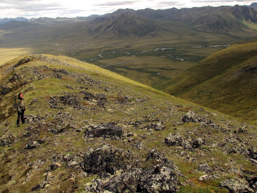
A view of the hillside or mountain from the Interpretive Center

Here are several views from the road going north from the CG:


Just a few miles north of the CG two streams come together. When rainfall conditions are right one of the streams is colored a bright pinkish brown and the other is clear. Unfortunately the colors didn’t come out as vivid in the photos as they did in real life.


Some views as you drive farther north


I thought the coloring on these kettle ponds was pretty


Wildlife we saw from the road
A beautiful red fox we saw running across the road and then stopping and looking at us from the bushes.


The fox’s tail is very bushy and ends in this white tip.

A blond grizzly about 1/2 mile from the road. Talking with a ranger later, this same grizzly was on the hillside across from the interpretive center and CG a few days ago.


Mountain Goats, or so you would think, looking without binoculars

But with binoculars it turns out they are just large white rocks. The park does have mountain goats which can be seen from the road, but we didn’t see any.

There were several horses grazing along the road. We assumed they belonged to an outfitter who has a camp nearby. I doubt the horses would survive the –40 degree temps they have here in the winter.


Hiking in the park
About 2 miles north of the CG a road branches to the east (right) to Goldensides trail. This trail in a moderate hike. About 3 miles round trip and elevation gain of about 700 feet. The trail is a fairly gradual climb. Beautiful views all along the trail


A selfie from along the trail

The view from the end of the trail

Some very pretty white and black lichen along the trail

And this interesting small plant which looks a little like Saguaro cactus, although much, much smaller.

Ranger led hike across the tundra
If the park is offering an all day ranger lead hike across the tundra, be sure to take it. Even if you have to stay a few extra days to take the hike. I believe which hike you go on depends on which ranger is going to lead the hike, so try to find out from the interpretive center where the hike will be going.
I considered this hike to be a moderate hike. We hiked for about 4 hours, traveled about 5.5 miles, with an elevation gain of about 1370 feet. We walked slowly so the trip was not overly strenuous. There was no trail. We just walked on the tundra, which was surprisingly easy to walk on. Kind of walking on very firm memory foam.
Even if this ranger led hike is not scheduled, you can take the hike yourself. We started the hike at the microwave tower relay station, on the west side of the road, about 15 miles north of the CG. GPS: 64.698157 -138.436153. We parked at the tower and walked up the tundra slope going NNW for about 1/3 to 1/2 mile. Then we followed a gradual slope along the hill side to the west towards the ridge in the distance. We topped out at the southern edge of the ridge at GPS: 64.679976 -138.439086. From there it was all down hill back to the parking lot.
There was only four of us on the hike, including the ranger. Wonderful when there are not bunches of people trying to hear the ranger talk.
Pictures from the hike.
Part way up the slope behind the Microwave Tower. The man in the picture was on the hike with his wife.

Just as we peaked out on the slope we saw the same grizzly Sharon & I saw yesterday


Some very interesting lichen I saw on the rocks


Jaw bone from a baby caribou.

My fellow hikers

Views

That is the Dempster Hwy in the right center of the photo.


Looking down on the Dempster Hwy. Also the young lady who was our ranger in the left center of the photo
Of course I had to get into one of the photos

Lunch break and a rest

Part way back down to the parking area.

Boondocking spot:
On our third day at the park we moved to a boondocking spot about 5 miles N of the CG. This is a large mostly level pullout with great views. GPS: 64.57556 -138.25127
BTW, that round thing on the roof of our motorhome is our Trav'ler automatic satellite dish with Dish Network service. We switched our Local Channels TV stations to Fairbanks, AK so we could have some kind of weather info. No cell phone signal here.


Views looking out our windows


Our drive from Tombstone Park back to the paved Klondike Hwy in the rain! An air leak in a tire!
The rain started shortly after we started our drive out of the park. It made the road a muddy mess, but it was NOT slippery.
About 15 miles from the CG my TPMS (Tire Pressure Monitor System) started beeping. We were loosing air from our passenger side rear outside dually tire. I was hoping it was just a slow lead so we could get to the paved highway and a nice wide spot to change the tire. Not to be. The pressure was dropping about 5-7 pounds a mile. (we were only driving about 15-20 mph) The only pulloffs we saw were extremely muddy. Much muddier than the road.
I finally pull to the side on a wide part of the road, put on some rain gear and went outside. Great news. The big awning extends over the rear tire. Before I got tooooo far along in starting to get everything out to change the tire, I checked the TPMS sensor on the valve stem. It was about 1/2 turn loose. I tightened it up and went back inside to monitor the pressure. Hurray, the air pressure stopped going down. The sensor was just a little loose, letting some air leak out of the tire. I got the air compressor out and aired up the tire and we were on our way. Only about a 45 minute delay.
A few more miles and we were back on paved road, the Klondike Hwy heading toward Whitehorse, YT.
From the junction of the Dempster and Klondike highways it is 306 mile drive to Whitehorse. For us that is a two day drive, especially after spending over 2 hours on the muddy road coming out of Tombstone Park.
We stopped for the night at Five Fingers Rapids, at KM380 on the Klondike Hwy.
Next up. Five Fingers Rapids, driving to Whitehorse and the remainder of our Alaska Trip.
Link back to the Alaska blog index page.
No comments:
Post a Comment