A side trip to McCarthy and Kennecott Mines National Historic Landmark is well worth the effort if you have the time. Also once you get to Kennecott, take the 4 mile round trip hike to Root Glacier. Two links to NPS info about Root Glacier hike:
https://www.nps.gov/wrst/planyourvisit/upload/Root-Glacier-Erie-Mine-Trail.pdf
www.nps.gov/wrst/planyourvisit/upload/Root%20Glacier%20Update%2012-2.pdf
Root Glacier is the only easy to access glacier I found in Alaska.
Picture of Kennecott Mines from the NPS website

OPTIONS FOR VISITING MCCARTHY AND KENNECOTT. To drive there is about 60 miles of good but a little bumpy gravel road. from Chitina to McCarthy. There are commercial transportation options, including flying in for a day trip. I did not research the commercial options.
-- Park your RV at an RV Park in Kenny Lake and drive your tow vehicle or toad about 2.5-3 hours one way to McCarthy. (RV Park info farther down) The first 27 miles are on a good paved road to Chitina, about 35-40 minute drive, and the last 60 miles (2 hours) on a good gravel road. More info about the road farther down.
-- Dry camp about 1.5 miles past Chitina and drive your tow vehicle or toad on the 60 mile gravel road to McCarthy. Two dry camping options here. Details farther down.
-- Take your RV on the gravel road to McCarthy. If your research shows enough for you to do to stay for 4-5 days (3-4 nights) then I would say go ahead and take your RV. For an overnight or 2 night trip, then don’t take your RV. There are cautions about driving the gravel road. Details farther down.
Road Guide to McCarthy Rd: https://www.nps.gov/wrst/planyourvisit/mccarthy-road-guide.htm
Info about McCarthy and Kennecott Mines.
Link to NPS information website: https://www.nps.gov/wrst/planyourvisit/mccarthy-road-and-kennecott-area.htm
-- To get to McCarthy is a 60 mile drive on a gravel road, which by many reports is an absolute “no, no” even in a 4x4 SUV. There are also reports of old railroad spikes sticking up, just waiting to poke a hole in your tires. As usual the reports are blown way out of proportion. I found the road to be in good condition. Little to no wash board. There are some pot holes, but nothing really bad. The road conditions could change based on the weather. In May 2015, (Bob) McQuade drove his Toyota Prius to McCarthy w/o incident. Details in his blog here. I drove my mid sized p/u with no problems. The road is wide enough for 2 vehicles to pass. However there is no shoulder. The road drops off about 1 1/2 to 3 feet if you stray off the edge of the road. Drive slow and carefully. Pull to the side and slow down to 10-20mph when oncoming vehicles approach to be safe. Better yet, pull to the side and stop for oncoming vehicles. Keep in mind this is a road many people drive every day. People live and work in McCarthy. They drive their vehicles to and from there. Tour Vans bring people there every day in tourist season. Trucks bring supplies to the area. It is not like this is some backcountry deserted road. On the other hand I only saw about 10-15 other oncoming vehicles on my 60 mile 2 hour drive. Not much traffic. However there is no cell phone signal until you get to McCarthy. I had a strong Verizon cell signal in McCarthy and at the camping/parking area at the foot bridge. Also good Verizon at the Copper river bridge near Chitina. No gas or vehicle service anywhere in the area except gas in Chitina and Kenny Late.
-- I did drive our toad (Chevy Colorado p/u truck) pretty slowly, about 30-35mph most of the way. It took me almost two hours to drive the 60 miles. About 3 or 4 times I had to slow down to about 5mph to navigate a pot hole or two. A number of times I slowed down to 15-20mph to maneuver around pot holes. Almost no washboard, which was nice. If you wanted to beat up your vehicle you could drive 45-50mph, but you can’t dodge the pot holes at that speed. I was able to miss 80%-90% of the pot holes. There is about 16 miles of paved road, starting about 4 miles from the bridge over the Copper River. In 2016 this paved road was in very good condition. Note: We parked our MH in a camping area about 1.5 miles past Chitina and I drove our Chevy Colorado to McCarthy. Sharon stayed at the RV since there is NO handicapped access at McCarthy or in getting to Kennecott.
-- If, in your research, you find enough things to do in McCarthy and the area to spend 3-4 nights, I would not hesitate to drive a RV. Just plan on going slow and take about 2.5-4 hours for the drive. The road will rattle and bounce your RV some. If you take your time and go slow you shouldn’t have to worry about flat tires. DO be sure to have a full size spare tire, the tools and ability to change the tire.
-- I saw several 25’-28’ Class C MH’s, a number of Vans and Class B’s and a good number of cars and SUV’s, either driving on the road, or at the camping/parking area.
-- There is no public vehicle access to McCarthy. You park ($5 for the day) at or near the end of the road and walk on a foot bridge across Kennecott river. From there it is a 1/2 mile walk to McCarthy, a 5 mile hike to Kennecott, or at the foot bridge pick up the shuttle van ($5) to town or Kennecott. Take the van it is a long walk to Kennecott. The residents have a road & bridge to town, but it is not open to the public.
-- Camping or overnight parking at McCarthy. Your best bet is to pay $20/night and park your RV on the hard packed gravel at the end of the road. No dump or fresh water available. Dry camping only.
Picture of the camping area from the foot bridge to McCarthy:

Closer view of the camping area.

Info about Camping at Kenny Lake or Chitina:
-- Kenny Lake: We didn’t stay at an RV Park in the area. For info go to RVParkReviews.com: http://www.rvparkreviews.com/regions/alaska/copper-center/kenny-lake-mercantile-rv-park-10380
We did park overnight on a very nice, quiet paved pullout, about 200 yards past Kenny Lake. GPS: 61.732522 -144.938628 We had Verizon cell phone reception in Kenny Lake.
We parked down the paved loop pullout on the right, about 100 yards past the trees.

-- Chitina: Actually about 1.5 mile past Chitina, across the bridge over the Copper River. There are two places.
-- A free Alaska DOT campground with about 10-14 sites under the trees with muddy ground to walk on if you get out. There are about 3-4 campsites large enough for 35-40 footer’s and several more for 25-30’ RV’s. This campground is on the RIGHT about 1/4 mile past the end of the bridge. GPS 61.528270 -144.403861
-- The other is a camping on the LEFT side across from the DOT CG. GPS 61.529626 -144.406988 This area is the on Alaska Native Corporation land and they charge $25/night. Self registration. If you don’t pay you could be accused of trespassing and fined (arrested?), or at the least be made to pay the camping fee. This is native land so you are subject to their laws, not Alaska laws. This parking/camping area is right on the Copper River in the open with good views and is fairly level. It is not muddy. You park on hard packed gravel.
We really don’t like being in the trees, so in spite of really thinking the $25 was a rip off, we paid the fee. In this same area there is a one acre area of NF land with free parking and boat launch. BUT it is not marked as to where it starts or ends. Park in the wrong place and you could get in a dispute with the Native Alaskans.
We had good Verizon cell service at our camping area
Our camping spot & view.


Back to our stay here and my day trip to McCarthy and Kennecott
-- I didn’t try to take our MH to McCarthy. Partly because I wasn’t sure of the road condition. Mostly though I didn’t take the MH because of the lack of good info about what to expect on the road and where to park/camp once we got to McCarthy. To complicate matters there was no way for Sharon to visit McCarthy and Kennecott. There is no handicapped access to the town or the mine. If she was able to get to the Kennecott mine buildings she could have driven her scooter around the are. Since I knew we were not going to spend 3-4 nights at McCarty I didn’t want to drive the MH that far on the gravel road just for a 2 night 1 day stay.
I made a day trip in our truck to McCarthy and enjoyed the trip, the town, the mine buildings and hiking on the Root Glacier. I felt it was well worth the effort to visit the McCarthy area.
I left camp about 6:45am and over all had an easy, but slow drive.
A few miles from camp the road goes up on a bluff with a great view of the Chitina river.

On the paved part of the road, as I rounded a bend there was a small black bear on the road. It started looping down the road in front of me and then turned back to look a me before disappearing into the brush.


Farther along there were two swans on a pond nicely lit by the morning sun.


At McCarthy, I parked at the foot bridge, paid my $5 fee to the attendant and walked across the bridge to catch the 9am shuttle. The shuttle runs every 30 minutes. Link to the website for the shuttle for more info and the schedule.
The foot bridge

Kennecott river from the footbridge

Some photos of Kennecott


The same buildings, but from the top. Little or no restoration work on the upper part yet.


The electric power plant for the mine.


The important people, working at the mine, had their families with them and lived in some nice cottages.


Hike to and short walk on Root Glacier
After checking out the buildings at the mine, I took a very nice 4 mile round trip hike to Root Glacier. (click on the link for NPS PDF doc about the hike). Root Glacier is the only glacier I found in Alaska with easy access to walk on the glacier.
The first 1.6 miles is an easy walk and the last 400 yards or so is considered moderate. The last part has some ups and downs and the last 200 yards is on fairly loose rock.
Picture of the last 100 yards or so:

View of the tongue of the glacier and a tour group putting on their crampons before going onto the ice. Crampons are spikes you strap on the bottom of your boots to walk on ice. Info from Amazon
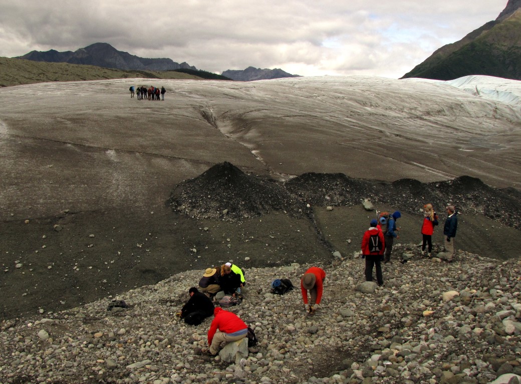
A view of Root Glacier with hikers on the glacier.

I didn’t have any crampons but knew from a walk on a glacier in Jasper NP in Canada, many years ago, you can walk on a glacier with lugged soled boots. You do need to be careful not to slip. To go any distance you really want to have crampons.
The ice melts into little peaks, with about 2-4 peaks per square inch. The lugs on your boots stick just fine to the sharp ice peaks. Not as well as the crampons, but well enough to walk for a couple hundred yards or so.
Close up of the ice showing the sharp peaks. My hat is there for a size perspective.

A closer look at the rough and jagged ice.

A tiny crevasse, only about 2-3” wide

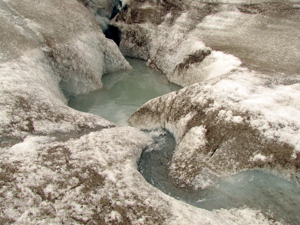
Ice melt running into an drain hole. Don’t fall in or you could get sucked down if there was a lot of water flowing. Not to mention it would be impossible to get out w/o help.

Kennecott Glacier
In this photo of Kennecott Glacier, look closely at the gravel in the distance. That is a glacier out there, it is just covered with gravel. You should be able make out 4-5 different color bands of gravel. Standing at this same place I counted 6 or 7 bands of gravel.

Root Glacier flows into the larger Kennecott Glacier. While the Root Glacier has exposed ice, the Kennecott is covered with rock and gravel debris.

Downtown McCarthy
There is not much to McCarty. A couple or three hotels and a restaurant. Several B & B’s in the area and some number of private homes. Kind of a funky, but interesting little town. There is a small museum with lots of historic photos of the area. McCarthy is not actually a town, it is a privately owned community. No government, no taxes. There is some sort of owners council or organization to oversee the the town.
Note the dirt streets in the pictures below. Looks like something out of an old west movie.


Then the 2 hour drive back to our camping spot.
The only thing unpleasant about this day trip was the drive back. Oh, the drive was as easy and uneventful as the drive out. It was just the need to “drive” 2 hours back after a day of activity. I never cared much for day trips. Way back when the kids were young and we went camping for weekends, Sharon would say “instead of all the packing and unpacking for going camping for the weekend, why don’t we just pack a lunch and drive the 2 hours to the river spend the day and then come home”. All the driving for just the day, especially the trip home, just did not excite me.
That's all for this entry. Next we move on to the eastern part of Wrangle St Elias National park and then to Tok and soon our departure from Alaska.
Link back to the Alaska blog index page.
No comments:
Post a Comment